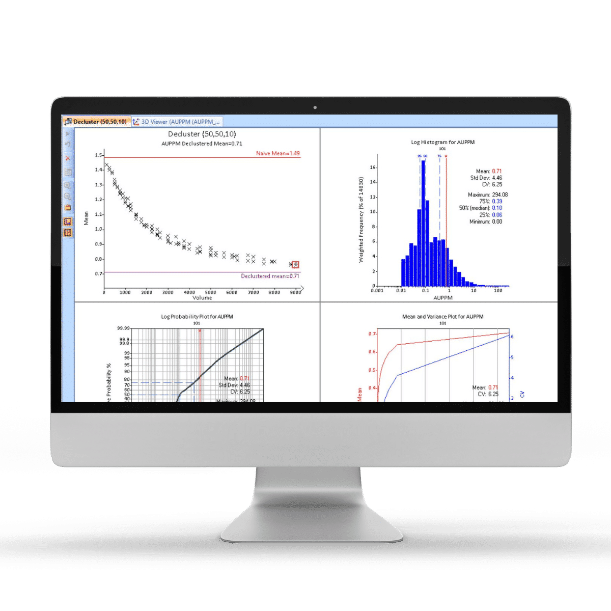
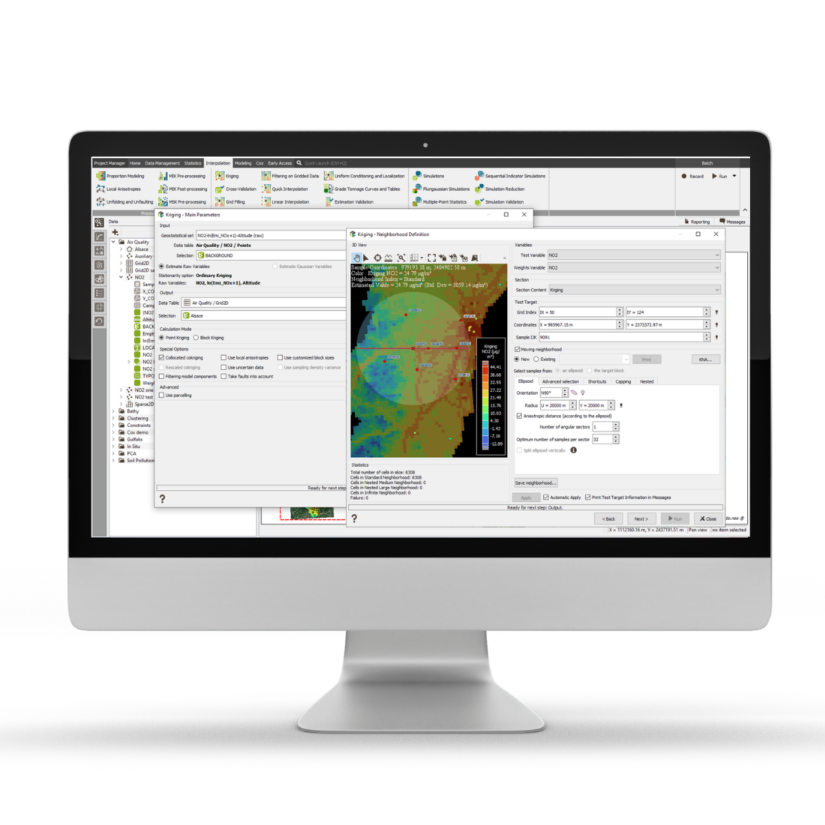
Skip to content
  • Products
    • Exploration
      • GIS on ArcGIS Pro
      • GIS on MapInfo
      • Modelling
    • Geological Data
      • Core Logging
      • Sample Collection
      • Data Governance
      • SABLE
      • Mine Mapping
      • Face Mapping
      • Geotechnical Mapping
      • Photogrammetry
      • QA/QC & Analytics
      • Windows-Based LIMS
      • Web-Based LIMS
      • Core Tracking
    • Resources & Reserves
      • Modelling & Evaluation
      • Enhanced Estimation
      • Advanced Geostatistics
      • Stratigraphic Deposits – Minerals
      • Stratigraphic Deposits – Coal
      • Ore Control & Dilution
    • Underground Planning
      • Strategic & Detailed Design
      • Production Scheduling
      • Scenario Analysis
      • Drill & Blast
      • CAD/Survey
      • Ventilation Modelling
      • Cellular Automata Model
    • Open Pit Planning
      • Strategic Planning
      • Strategic Analysis
      • Design & Scheduling – Minerals
      • Design & Scheduling – Coal
      • Detailed Excavation Analysis
      • Drill & Blast
      • Surveying
    • Operations
      • Short Interval Control
      • OP Drill & Blast
      • UG Drill & Blast
      • Fragmentation Measurement
      • Production Geology
      • Ventilation Modelling
      • Reticulation Design
      • Production Planning & Reporting
      • Diesel Emissions Management
    • Supply Chain
      • Blending & Optimisation
      • Inventory & Logistics
      • Metallurgical Accounting
      • Commodity Trading
      • Reconciliation
  • Services
    • Training
    • Online Learning
    • Advisory Consulting
    • Specialised Implementations
  • Support
    • Portal & Downloads
    • Request Access To Support
  • Community & Resources
    • News
    • Newsletter
    • Events
    • User Forum
Datamine
  • Community & Resources
    • News
    • Newsletter
    • Webinars
    • Events
    • Customer Success Stories
    • LinkedIn User Forum
    • Vimeo
    • YouTube
  • About
  • Contact
    • Find Your Closest Office
    • Careers
  • EnglishEnglish
    • EnglishEnglish
    • EspañolEspañol
    • РусскийРусский
  • Search

PixPro Partnership Means Streamlined Workflows for Drone Capture and 3D Modelling is Now Possible

Posted on December 1, 2020December 18, 2020 by Kristy Marshall

PixPro Partnership Means Streamlined Workflows for Drone Capture and 3D Modelling is Now Possible

Pix Pro - Advanced Contour Line Drawing

With Datamine’s partnership with PixPro, you can now utilise intelligent tools to capture and manage your geological images for 3D modelling and analysis.

“We’re excited to be working with PixPro more closely, as it means more benefits for our clients including easier integration, working with one team rather than separate companies, and overall pricing benefits when signing up for the bundled products.” – Ben Vagg, Product Manager, Studio Survey, Datamine.

Edvardas Ramanauskas, CEO, PixPro said, “Working with Datamine brings the PixPro solution to a lot more mine sites around the globe – a prospect we’re very happy about. We’re committed to working with the Datamine team to continuously innovate and deliver a solution that is customer-driven.”

“Partnering with Pixpro means that we’re able to take the data captured from drones and other image capture technology and access even better quality 3D modelling. A prospect we know will be hugely beneficial to our clients and which we are excited to continue developing even further” said Ian Anderson, Product Manager, Studio Mapper and Sirovision at Datamine.

What is Datamine PixPro?

Datamine PixPro is an advanced Photogrammetry software utilising data capture from drones and a range of other captures. Designed to provide fast data-driven insights, Datamine PixPro provides the most efficient, sustainable and cost-effective solution. Easy integration with Sirovision, Studio Survey and other Datamine products.

Key Features include:

Intuitive Photo Manager

A wide range of photo management options enables the user to process the photos acquired by any photographic source. With Photo Manager you can also easily review, arrange, select or deselected the specific photos for further data processing.​

Highly Detailed 3D Terrains

Object visualisation in 3D mode has never been so easy – no matter the size of the object, navigate through different views without sacrificing performance or accuracy. ​The large data visualisation engine enables you to zoom in, zoom out, drag the zone of interest from one object to another, maintaining visual clarity.

Dense Point Clouds

Dense point clouds are the key elements in creating a 3D mesh from the original 2D footage. Denser 3D point clouds result in higher resolution, more detailed textures and improved precision.
Average processing scenarios​:

  • 367 photos covering approx. 240,000m²​
  • Low density dense point cloud of 13.9M points GSD of 0.34m processing time 1hr 21min​
  • High density dense point cloud of 27.0M points GSD of 0.02m processing time 2hr 39min​

Object Comparison Over Time

This feature allows you to monitor how an object changes with time and access valuable information for effective resource and workflow planning. ​It also enables you to monitor changes in stockpiles, including building and depletion.

Advanced Contour Line Drawing

With a wide range of options for operating with the contour lines, you can select whether to draw:

  • A set of contour lines by defining the necessary spacing between the lines;
  • Each contour line separately without the need to add spaces between different lines.

​Draw a separate contour line to showcase the needed level. This feature provides visibility at the specific element level. You’ll be able to easily drag it up and down, till you find the suitable height, add new contour lines one by one, highlight only those that you need, and measure the distance between the selected contour-lines.​

2D and 3D Measurements

Calculate the precise measurements and analyse the object by using:

  1. Point, ​
  2. Line (distance),
  3. Profile (distance, altitude, angle), ​
  4. Polygon (slope, volume, perimeter), ​
  5. Surfaces – the 2D & 3D perimeter and 2D & 3D area, ​
  6. 3D volume, height and base area.

Get the precise measurements of the stockpile crest by using a draped line option.​

To learn more about Datamine PixPro, visit the product page here, or request a demo here.  

Want a sneak peek? We recently presented at the Amira Global Roar on 3D Modelling Using Drone Captured Footage including a PixPro demo – access it here.

CategoriesBlog, Current Newsletter, News, Resources & ReservesTags3d analysis, 3d modelling, 3d terrains, contour line drawing, dense point clouds, drone data capture, drone imagery, drone technology, photogrammetry, pixpro, sirovision, studio surveyPosted on December 1, 2020December 18, 2020

Share

Post navigation

Previous post:PixPro Partnership Means Streamlined Workflows for Drone Capture and 3D Modelling is Now Possible
Next post:PixPro Partnership Means Streamlined Workflows for Drone Capture and 3D Modelling is Now Possible

Leave a Reply Cancel reply

Your email address will not be published. Required fields are marked *

Our Solutions

  • Exploration
  • Geological Data
  • Resources And Reserves
  • Underground Planning
  • Open Pit Planning
  • Operations
  • Supply Chain Management

Social

  • Facebook
  • LinkedIn

About Us

Support

Contact Us

  • Find your location
  • sales@dataminesoftware.com

Datamine is a world leading provider of the technology and the services required to seamlessly plan and manage mining operations.

Learn more Learn more

Subscribe To Our Newsletter

  • Terms and Conditions
  • Privacy Policy
Copyright © 2021 Datamine Website by Web3 Brisbane
  • Products
    ▾
    • Exploration
      ▾
      • GIS
      • Modelling
    • Geological Data
      ▾
      • Core Logging
      • Sample Collection
      • Data Governance
      • Mine Mapping
      • Geological Mapping
      • QA/QC & Analytics
      • Windows-Based LIMS
      • Web-Based LIMS
      • Core Tracking
    • Resources & Reserves
      ▾
      • Modelling & Evaluation
      • Advanced Geostatistics
      • Stratigraphic Deposits – Minerals
      • Stratigraphic Deposits – Coal
      • Ore Control & Dilution
    • Underground Planning
      ▾
      • Strategic & Detailed Design
      • Production Scheduling
      • Scenario Analysis
      • Drill & Blast
      • CAD/Survey
      • Ventilation Modelling
    • Open Pit Planning
      ▾
      • Strategic Planning
      • Strategic Analysis
      • Design & Scheduling – Minerals
      • Design & Scheduling – Coal
      • Detailed Excavation Analysis
      • Drill & Blast
      • Surveying
    • Operations
      ▾
      • Short Interval Control
      • OP Drill & Blast
      • UG Drill & Blast
      • Fragmentation Measurement
      • Production Geology
      • Ventilation Modelling
      • Reticulation Design
      • Production Planning & Reporting
      • Diesel Emissions Management
    • Supply Chain
      ▾
      • Blending & Optimisation
      • Inventory & Logistics
      • Metallurgical Accounting
      • Commodity Trading
  • Services
    ▾
    • Training
    • Advisory Consulting
    • Specialised Implementations
  • Support
    ▾
    • Portal & Resources
    • Request Access To Support
  • Community & Resources
    ▾
    • News
    • Newsletter
    • Webinars
    • Events
    • Customer Success Stories
    • LinkedIn User Forum
    • Vimeo
    • YouTube
  • About
  • Contact
    ▾
    • Find Your Closest Office
    • Careers
  • EnglishEnglish
    ▾
    • EnglishEnglish
    • EspañolEspañol
    • РусскийРусский